By Jorge Láscar from Australia - Troy (and a trojan horse), CC BY 2.0
The city of Troy was a major center of trade and commerce during the Bronze Age. It was located on the northwest coast of modern-day Turkey, near the entrance to the Dardanelles, a strategic waterway that connects the Aegean Sea to the Sea of Marmara and the Black Sea. It was strategically located on a hill overlooking the surrounding plains, which made it a natural defensive position.
Troy was a city, both factual and legendary, in northwest Anatolia in what is now Turkey. In Classical Greek, the city was referred to as both Troia (Τροία) and Ilion (Ἴλιον) or Ilios (Ἴλιος). It is best known for being the setting of the Trojan War described in the Greek Epic Cycle and especially in the Iliad, one of the two epic poems attributed to Homer. Troia was added to the UNESCO World Heritage list in 1998.
Troy was protected by a series of walls and gates, which was repeatedly destroyed and rebuilt during its 4000 years of occupation. As a result, the site is divided into nine archaeological layers, each corresponding to a city built on the ruins of the previous. Archaeologists refer to these layers using Roman numerals, Troy I being the earliest and Troy IX being the latest.
Troy was first settled around 3600 BC and grew into a small fortified city around 3000 BC (Troy I). Among the early layers, Troy II is notable for its wealth and imposing architecture. During the Late Bronze Age, Troy was called Wilusa and was a vassal of the Hittite Empire. The final layers (Troy VIII-IX) were Greek and Roman cities which served as tourist attractions and religious centers because of their link to mythic tradition.
Troy VII has been identified with the Hittite Wilusa, the probable origin of the Greek Ἴλιον, and is generally (but not conclusively) identified with Homeric Troy.
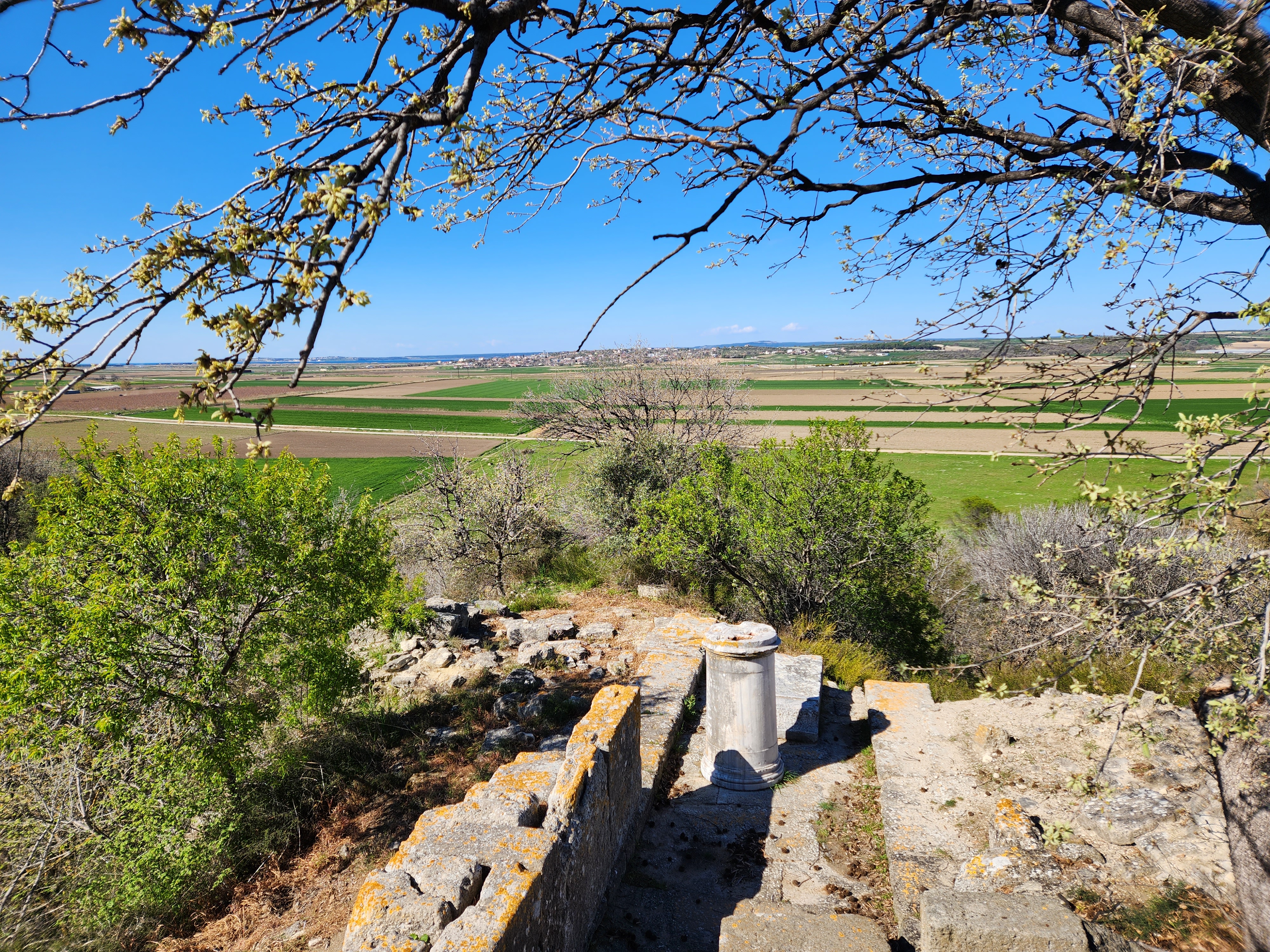
Photo Gallery
The below photos were taken on 03/30/2023.
View of the southwest-side ruins near the entrance (Troy VI is on the right; see the below picture)
The East Wall and Gate
The total circumference of the Late Bronze Age fortification-wall around the citadel amounts to 550 meters, of which approximately 330 are still preserved. The section displays a highly refined technique of construction, with careful working of the rectangular limestone blocks.
The East Tower and East Gate of Troy VI (Late Bronze Age, 1500-1300 B.C.)
The Temple of Athena (Troy VIII-IX)
The Temple of Athena belongs to the Greek and Romain city of Ilion. The temple, whose base measured 36m x 16m, was surrounded by a Doric colonnade supporting a coffered ceiling. Outside, on the entablature, were metopes (reliefs), the most famous of which shows Apollo/Helios. This is now displayed in Berlin. The temple was probably under construction for nearly a century, from ca. 240-150 B.C. It was restored in Romain times, probably by order of the Emperor Augustus (31 BC-AD 14). In Greek and Romain times the temple was the focal point of a great annual festival in honor of the goddess Athena. This festival was marked by sacrifices and athletic contests.
The Temple of Athena. Reconstruction of he colonnade before the entrance.
The exterior of the citadel walls of Troy II and III (ca. 2550-2200 BC), those of the Burnt City of Schliemann.
The protective roof built during the summer of 2003 was used to keep megaron as well as the preserved stretch of fortification wall visible to the public without endangering the original mudbrick masonry. The roof not only conveys the more rounded form of the mound before excavation, but has even been positioned to reflect the approximate height of the mound when Schliemann arrived in 1871. The shape, moreover, resembles a billowing sail, recalling the nearly constant northeasterly winds that certainly did bring riches to the site. A ancient ships were compelled to bide their time in Beşik Bay awaiting a breeze from the southwest that would take them through the straits and onwards toward the Black Sea.
A Quiet Day in a Berlin Park, 1933 In the early 1930s, Takehisa Yumeji's studio became a hub for artists, inspiring ventures like the Mt. Haruna Art Research Institute. In 1931, Yumeji began a journey to the United States and Europe, supported by exhibitions of his work. While in the U.S. for 16 months, he continued to paint, creating pieces like Nude on the West Coast. Afterward, Yumeji taught in Berlin until the school was closed by the Nazis. He returned to Japan in 1933, his overseas experiences shaping his final works. His last exhibition was held in Taipei that year. Yumeji passed away from tuberculosis in 1934, leaving behind a legacy of beauty and cultural exchange. Read more: Prints in Collection—Takehisa Yumeji (1884-1934) Kuronosuke 黒の助: a Legacy Little Black Cat (YouTube link ) Photo Gallery The Yumeji Art Museum in Okayama exhibits many black cat paintings because the artist, Yumeji Takehisa , frequently featured them in his work, particularly in his bij...
Hagi City , Yamaguchi Prefecture, Japan, is a UNESCO World Heritage Site renowned for its maritime and historical significance, particularly from the Edo period and Meiji Restoration . This coastal town captivates with its well-preserved samurai districts, pine-lined roads, clear waterways, and serene ambiance, evoking a nostalgic journey back in time. Historical figures like Yoshida Shoin and Shinsaku Takasugi shaped its legacy. Cycling, boat trips, temple visits, and local specialties like summer tangerines and Hagi ware highlight Hagi’s charm. Hidden gems like Tokoji Temple make it a must-visit for an authentic, enriching experience. Japan’s Timeless Beauty – 2 Days in Hagi, a World Heritage Town (YouTube link ) Things to Do Boat Trip: A 40-minute sightseeing boat tour provides a unique perspective of Hagi, with reflections on the town’s historical significance during the ride. Bicycle Rental: You can rent a bike at the station, which is a recommended way to explore Hagi. C...
Koyasan (高野山), a popular pilgrimage destination for centuries, has been connected to the outside world by a network of pilgrimage trails. While most visitors enter the mountain by cable car nowadays, many of the pilgrimage trails still remain in use. Koyasan Travel—Temple Lodging (Shukubo; YouTube link ) Part of the pilgrimage trails, the Fudozaka Trail (不動坂; click the map to enlarge), leads to Koyasan from Gokurakubashi Station, the lower station of the Koyasan Cablecar. The steep, paved trail is 2.5 kilometers long and takes about an hour to ascend and less time to descend. The trail ends at the Nyonindo temple (女人堂). [1] On 11/27/2016, I have decided to descend from Fudozaka Trail instead of riding the cable car. I was the only person on the trail at beginning. However, in the middle of the trail, another young blonde girl passed me by swiftly with a big smile on her face. I was really surprised to see another soul on that rainy day. Althoug...

_(8709942456).jpg)