
Spain Travel—Barcelona Public Transportation Basics
Video 1
 |
| Figure 1. Barcelona City Center |
Barcelona Metro Map
The map (Barcelona Metro Map PDF) shows both TMB, FGC and TRAM lines in Zone 1 which cover the city centre.
- TMB (Transports Metropolitans de Barcelona) lines
- L1, L2, L3, L4, L5, L9
- FGC (Ferrocarrils de la Generalitat) lines
- L6, L7, L8
- Tram Lines
- T1 to T4
Together they form the Barcelona Metro system.
 |
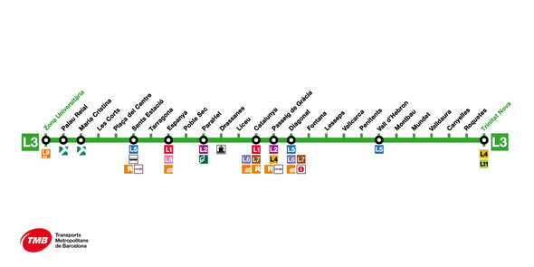
| Figure 2. Line 1 & L3 Map at Train Station |
Barcelona L1 & L3
LINE L1 - Red
The red line crosses the whole city from east to west and stops at many tourist places such as the Arc de Triomf (Parc de la Ciutadella), Plaça Catalunya and Plaça d'Espanya.
Its main connections are with the yellow line at metro station Urquinaona, the green line at Plaça d'Espanya, the purple line at Plaça Universitat or Clot and the blue line at Sagrera-Meridiana or Plaça de Sants.
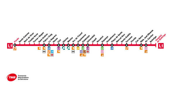
LINE L3- Green
Video 2
Transportation between Barcelona Airport (BCN airport) and City Center
Barcelona’s transport system has changed since this article was first published. For the latest rules on T‑Casual, T‑mobilitat, and airport transfers, read the updated 2026 guide: 👉 Buying the T‑Casual at Barcelona Airport (BCN): Updated Guide for 2026
References
- How to use the T-10 Ticket in Barcelona (Important)
- T10 card purchase at Barcelona Airport (BCN airport)
- Barcelona Metro : map, stations, pass, tickets, prize..
- Using a credit card in Spain
- Chip-and-PIN Credit Cards in the USA
- Josep Tarradellas Barcelona-El Prat Airport (BCN)
- Finding public restrooms in Barcelona
- No toilets in underground stations


